Ibn Sīnā (Avicenna) in Isfahan: A Geospatial Critique of his Imagined Past in the City

Left: A general view of the building known as Ibn Sīnā’s Madras in Isfahan ca. 1970’s. (Honarfar, Lotfollah. Ganjīnah-yi āṣār-i tārīkhī-yi Iṣfahān [A treasure of historical monuments of Isfahan]. 2nd ed., Saghafi Bookshop, 1971. p.47) Right: An internal view of the building known as Ibn Sīnā’s Madras in Isfahan (Shahsanaei, Peyman. Madras-i Ibn Sīnā. Photograph, 2022, https://www.isna.ir/photo/1401060100203 .)
Overview
In the Dardasht district of Isfahan (Iran) stands a dodecagonal, domed building known as the Madras-i Ibn Sīnā (Academy of Avicenna). It is widely believed to be the site where Avicenna (Ibn Sīnā, 980–1037 CE), the renowned physician-philosopher and polymath, taught students during his residence in Isfahan (1024–1037 CE).
I used digital mapping to critically assess this claim through geospatial visualization of two historical datasets: one extracted from a wide range of primary and secondary literature on the urban history of Isfahan, and the other from Avicenna’s biobibliography. By geolocating textual evidence and georeferencing historical maps of Isfahan, I reconstructed a spatial model of the city during Avicenna’s time.
This enabled me to analyze the spatial relationship between the Madras and Avicenna’s documented whereabouts and scholarly activities. My analysis reveals that the building’s location and its speculated function are not consistent with the geolocated historical data.Georeferencing a raster map of Isfahan’s historical urban arteries (Gaube, Heinz. “Iranian Cities.” The City in the Islamic World (2 Vols.), Brill, 2008, pp. 159–80. p.1173) and digitizing roads as line features in ArcGIS Pro
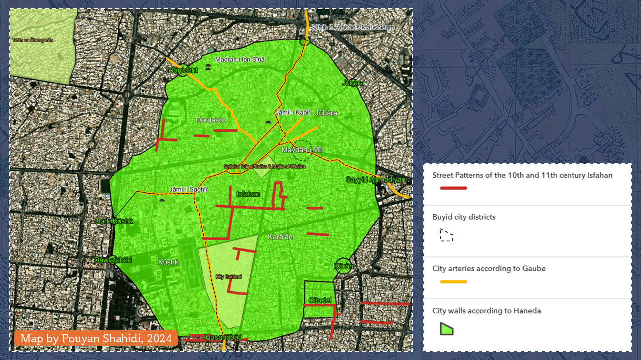
Spatial reconstruction of the 10th–11th century CE Isfahan
Software
ArcGIS Pro 3.1, ArcGIS Online, ArcGIS Instant Apps
Data
- Temporal point data in CSV format extracted from primary and secondary literature
- Raster data of multiple digitized print maps
- Line and polygon data extracted from georeferenced raster
Skills used
Data extraction from unstructured sources, Point data structuring in CSV format, Georeferencing raster maps, Data digitization and feature extraction, Vector data creation (points, lines, polygons), Geodatabase design and management, Feature class creation, Web map deployment via ArcGIS Online, App configuration using ArcGIS Instant Apps